


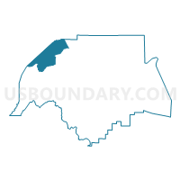
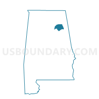
New Union Community Center, Etowah County, Alabama
About
Outline

Summary
| Unique Area Identifier | 521787 |
| Name | New Union Community Center |
| County | Etowah County |
| State | Alabama |
| Area (square miles) | 25.54 |
| Land Area (square miles) | 25.51 |
| Water Area (square miles) | 0.02 |
| % of Land Area | 99.90 |
| % of Water Area | 0.10 |
| Latitude of the Internal Point | 34.12528160 |
| Longtitude of the Internal Point | -86.23096910 |
Maps

Graphs
Select a template below for downloading or customizing gragh for New Union Community Center, Etowah County, Alabama


Neighbors
Neighoring Voting District (by Name) Neighboring Voting District on the Map
- Boaz Rec Center, Marshall County, AL
- Morton Chapel Church, Etowah County, AL
- Mountainboro City Hall, Etowah County, AL
- Mt Hebron Fire Dept, Marshall County, AL
- Pine Grove School A-D, Marshall County, AL
- Sardis City Hall, Etowah County, AL
- Walnut Grove Vol. Fire Dept., Etowah County, AL
Top 10 Neighboring County Subdivision (by Population) Neighboring County Subdivision on the Map
- Albertville-Boaz CCD, Marshall County, AL (37,950)
- Mountainboro CCD, Etowah County, AL (9,378)
- Douglas CCD, Marshall County, AL (6,028)
- Altoona CCD, Etowah County, AL (5,302)
Top 10 Neighboring Place (by Population) Neighboring Place on the Map
- Boaz city, AL (9,551)
- Sardis City town, AL (1,704)
- New Union CDP, AL (955)
- Walnut Grove town, AL (698)
- Bristow Cove CDP, AL (683)
Top 10 Neighboring Unified School District (by Population) Neighboring Unified School District on the Map
- Etowah County School District, AL (60,417)
- Marshall County School District, AL (47,197)
- Boaz City School District, AL (9,551)
Top 10 Neighboring State Legislative District Lower Chamber (by Population) Neighboring State Legislative District Lower Chamber on the Map
- State House District 26, AL (52,448)
- State House District 30, AL (44,979)
- State House District 29, AL (43,353)
- State House District 28, AL (40,514)
Top 10 Neighboring State Legislative District Upper Chamber (by Population) Neighboring State Legislative District Upper Chamber on the Map
Top 10 Neighboring 111th Congressional District (by Population) Neighboring 111th Congressional District on the Map
Top 10 Neighboring Census Tract (by Population) Neighboring Census Tract on the Map
- Census Tract 310, Marshall County, AL (6,028)
- Census Tract 312, Marshall County, AL (5,354)
- Census Tract 111, Etowah County, AL (5,302)
- Census Tract 110.02, Etowah County, AL (4,765)
- Census Tract 311, Marshall County, AL (4,688)